The 2015 El Niño is likely to strengthen in the coming weeks, largely due to recent tropical cyclone activity. Several tropical cyclones, including a rare July cyclone in the southern hemisphere, have resulted in a strong reversal of trade winds near the equator. This is likely to increase temperatures below the surface of the tropical Pacific Ocean, which may in turn raise sea surface temperatures further in the coming months.
I posted this picture the other day, including the rare (for this time of the year) TC Raquel:
Here's an updated wind map of a region of the western Pacific a bit further north:
The model outlook from BoM shows the likely strengthening of El Nino, with not that much of a spread between models:
Next an animation of sub-surface temperatures in the equatorial Pacific, down to 400m, starting in January 2014 through to June 2015. This year is different to last year. These are from BoM.
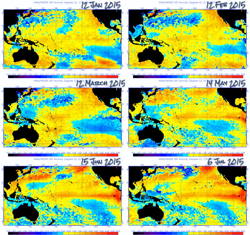
Finally, here's an animation of sea surface temperatures across the Pacific, from NOAA images starting in January this year:


This reminds me that GISTemp for June this year must be imminent. I'm expecting that the monthly anomaly value may even have an '8' immediately after the '.', and rival the values for February and March. Unless the oceans and southern hemisphere were particularly cool, which doesn't seem likely.
ReplyDeleteI think it will come out next week some time. I'll let you know.
DeleteStill no GISS Temp for June.
DeleteMy curiosity is itching...
The JMA estimates for June 2015 were released today.
DeleteI won't spoil the surprise...
http://ds.data.jma.go.jp/tcc/tcc/products/gwp/temp/jun_wld.html
Right now the anomaly forecast for early July looks very low. El Nino maybe ramping up, but global temperature, while very high, is in a stall since the end of 2014. The PDO has been down in every month this year. Nick's guys are predicting .77C for GISS for June.
ReplyDeleteThe nino34 region climate model forecasts for this week are out.
DeleteI won't spoil the surprise, but when I saw them I almost dropped my cup of coffee...
It is only a model forecast and I am ready to guess it is wrong. But the acceleration is so swift we will know how accurate it is by the end of the month.
Anecdotally I heard conditions are evolving so rapidly they are having to redo the more often than they usually do.
http://www.cpc.ncep.noaa.gov/products/CFSv2/imagesInd3/nino34Mon.gif
The Australian BOM dropped this interesting little comment. People can read between the lines as well as I can: they are implying the models are already out of date.
Delete"Due to strong NINO3.4 outlooks from all models, these graphs have been modified from last month to better present the forecast data."
Harry, interesting. That NOAA model is about 0.8C higher than BoM for November. We'll know in a week what the next BoM forecast is.
Deletehttp://www.bom.gov.au/climate/ahead/model-summary.shtml#tabs=Pacific-Ocean
The BOM model is about 10 days behind the NOAA model - things flow about so here, as Alice said.
DeleteBottom line is nino34 could be flirting with a 3C anomaly. From memory the 1997/98 El Nino was 2.3C (not sure about the baseline).
Prediction: Over at WUWT, they'll be screaming and jumping up and down, and old Bob Tisdale will say "See? I told you so!" and declare victory, and there will be lots of general mirth and backslapping. Over what, exactly, I don't know. But it will probably be something along the lines of proof at last that el ninos cause warming.
ReplyDeleteStogy